
Mu Aye Pu sits where the Dawna hills meet the Moei. The river is the road and the border. Forest begins at the back of the houses. Sandbars shift with the season. Karst peaks hold cloud. This page is a reading of that landscape: rock, water, plants, animals, and the long war that both hid the country from science and, with Karen law, left much of it standing. It is a landscape account, not a plant list for one clearing.
Setting
The village stands in the Dawna Tenasserim country, a spine of hills along the Thailand-Myanmar border. WWF has described that transboundary landscape as the largest remaining block of contiguous forest in mainland South-east Asia, on the order of eight million hectares. Mu Aye Pu is a riverside settlement on the Myanmar bank, not the whole of that forest. The right scale for public geography is the river, the foothills, and Kawthoolei. Coordinates are not published.
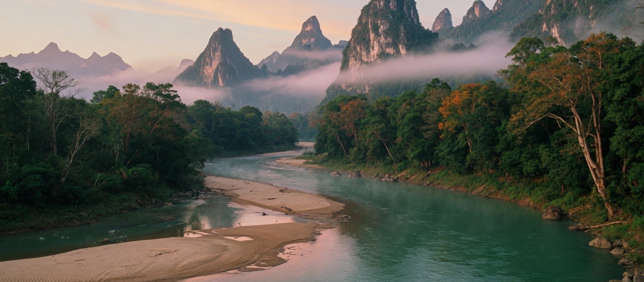
The Moei, also called the Thaungyin, is a tributary of the Salween (Thanlwin). Unlike most Thai rivers it runs north, along the border, past Mae Sot and Myawaddy, and joins the Salween at Sop Moei. For the village the river is habitat as well as frontier: sand, current, fish, boats, and the far bank of Thailand in plain sight. Place.
Geology and geomorphology
These hills belong to the Indo-Malayan mountain system, in rock that geologists group with the Sibumasu (Shan-Thai) block. The neighbouring Tenasserim Hills are mapped as Permian and Triassic granite and limestone. The limestone is what you see as karst: steep vegetated towers, cliffs, caves, and peaks that rise suddenly from the river flats. Granite underlies other ridges. The two together make a landscape of hard high ground and a softer valley floor.
The Moei has cut a border trench through that structure. In the dry season sandbars widen and the channel braids. In the wet season the river rises, the bars drown, and the bank becomes the only road that still works. Riparian flats, abandoned channels, and small agricultural clearings occupy the alluvium. Behind them the slope steepens at once into forested karst and mixed hill forest. Landmines and old posts are themselves landforms of a kind: ground that people do not walk.
This is a monsoon landscape. Moo, Froese and Gray, working in Karen hill forest, recorded a climate of about 1,500 to 2,000 millimetres of rain a year, with a wet season roughly from May to October, a cool dry season from November to February, and a hot dry season from February to May. The village on the river is lower and more seasonal than those camera sites. The pulse of the Moei is the local clock.

Vegetation
Lower slopes of the Dawna Karen hills carry mixed deciduous forest, including teak where it has not been cut. Evergreen and semi-evergreen monsoon forest takes the wetter folds and higher ground. Dipterocarps appear at lower elevations; montane forest higher up. Bamboo, banana and secondary growth mark village edges, old fields and riverbanks. Sacred forest, graveyards and the trees that belong to kaw law are part of the vegetation suite, not an extra. They are how some stands persist next to houses.
There is still no published plant list for Mu Aye Pu itself. Orchids, teak and dipterocarp are documented in the wider Kawthoolei and Peace Park literature. They are not listed here as if they were counted in this clearing.
Wildlife and biodiversity
Biologists have called Karen State the “dark side of the moon”: little census of people, less of species (Clingen, 2019). Myanmar holds some of the largest unsurveyed terrestrial areas in South-east Asia. Earlier national mammal reviews simply left Karen State out, for security and politics.
The first structured camera-trap work (Moo, Froese and Gray, Oryx, 2018) therefore matters. Six surveys in hill forest across northern Karen State, 2014 to 2015: 9,511 trap-nights, 4,191 records, at least 31 mammal species, 17 of them Near Threatened, Vulnerable or Endangered. Nineteen were carnivores. The assemblage included tiger, leopard, Asian elephant, sun bear, Asiatic black bear, dhole and gaur. Leopards were found at most stations and every site. The authors judged the landscape globally significant for a mammal community that has collapsed across much of its former range. They did not estimate abundance. They did not survey this village. Their cameras sat in hill forest between about 800 and 1,900 metres.
Later papers (Greenspan and colleagues, 2020, 2021, 2023) treat Kawthoolei as a conservation planning unit: species-distribution models, large-felid connectivity through the Dawna Tanintharyi landscape, leopard occupancy on the Kawthoolei-Thailand border. Paul, Roth and Moo (2021) describe Indigenous Karen conservation as relationship, not a park drawn from outside. All of that is landscape science. None of it is a bird, fish, insect or plant inventory for Mu Aye Pu.
The Sumatran rhinoceros is not treated as present here.
A public film series, KNDO Jungle Doctor, shows the village in 2018 and 2019 taking in two Asiatic black bears after poaching: a community partnership, not a zoo. That is Dr Sabine’s filmed record. A small cafe at the village, 2 Bears Cafe, later took their name. It once operated. It is not a wildlife park, and it is not a booking now. The bears.
War, knowledge gaps, and what the war accidentally kept
Armed conflict with the Burmese state began in 1949. Nearly eighty years on, it is still among the longest wars in Asia. For science that has meant closed ground: no safe transects, no long weather series, no public survey of this bank. The gaps are not an accident of scholarship alone. They are a product of mines, patrols, displacement, and the decision, on this site, not to publish coordinates or rare species maps that could be used against the forest or the people.
The same inaccessibility slowed industrial conversion. Clingen wrote that military clashes prevented settlement, roads and extraction around the Dawna Range, even as the rest of Myanmar opened to foreign industry after 2008. Moo, Froese and Gray said security issues had “slowed deforestation and preserved biodiversity in many areas,” and that ceasefire-era development would reverse that. Landmines and posts are a brutal form of land-use planning. They are not a conservation policy. They are a fact of the ground.
War is not the whole reason the forest still holds tiger and gaur. The camera-trap authors were plain: Karen stewardship, including inherited hunting taboos, is “directly responsible for the persistence of biodiversity in the region.” The Karen Forestry Department, from the 1950s, has laws and penalties for the hunting of tiger and elephant, and a sanctuary system. Wildlife Protection Units walk villages. KNDO rangers work forest around places such as Mu Aye Pu. Conservation is Karen labour, older than any later drawing.

People and wildlife, as the country opens
A diverse large-mammal community next to houses is, in Moo et al.’s words, “an encouraging testament to the possibility of human-wildlife coexistence.” The village is not a fortress park. Rice, fish, boats and forest law share the same bank. Some forest is hunted; some is forbidden. Rangers and taboos are the management system that already exists.
The danger is the other opening. After the 2012 ceasefire and the 2015 Nationwide Ceasefire Agreement, return, roads and outside interest in land arrived together. Hunting for the illegal wildlife trade showed on cameras, especially near the Thai border. Vacant-land law, dams on the Salween, and lodge or township drawings all treat forest as empty if it is not titled. The 2021 coup closed the ceasefire weather and returned airstrikes, including in the Salween Peace Park. Development and war can strip a landscape by turns.
Managing human-wildlife interaction here does not begin with a new brand. It begins with the people who already live in the hills: rangers, kaw law, KFD rules, KESAN and the Karen Wildlife Conservation Initiative, and guests who come slowly. Visit is guesting, not a viewing platform. Rare-species locations stay unpublished on purpose.
This settlement in a larger country
This is one village in a forested, karst, riverine landscape of Kawthoolei, where science is late, war has been long, and Karen people have kept more of the living country than the maps of Burma ever showed. The Salween Peace Park is that wider story, not an asset of this landing.